Tomaat Pass
From Guild Wars Wiki
Jump to navigationJump to search
| Tomaat Pass | |
|---|---|

| |
| Campaign | Factions |
| Region | Shing Jea Island |
| Type | Landmark |
| Images | |
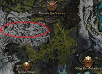
 Map of Tomaat Pass | |
Tomaat Pass is a north-south path through the western end of the snowy mountain range that stretches from Sunqua Vale to the western coast of Shing Jea Island. It connects the northern and southern areas of Kinya Province and provides access to the trail through the mountain range and into Sunqua Vale. Yeti are known to lair in caves along the pass.
Getting there[edit]
From Tsumei Village, follow the path north.
NPCs[edit]
Allies[edit]
Services[edit]
 10 Mi Fai (collector for 3 Forgotten Trinket Boxes)
Other allies[edit]
 10 Zho
Foes[edit]
 12 Red Yeti
Trivia[edit]
- In Dutch tomaat means tomato.